קובץ:Fort Douaumont location map 300px.jpg
מראה
Fort_Douaumont_location_map_300px.jpg (300 × 250 פיקסלים, גודל הקובץ: 53 ק"ב, סוג MIME: image/jpeg)
היסטוריית הקובץ
ניתן ללחוץ על תאריך/שעה כדי לראות את הקובץ כפי שנראה באותו זמן.
| תאריך/שעה | תמונה ממוזערת | ממדים | משתמש | הערה | |
|---|---|---|---|---|---|
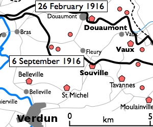
| נוכחית | 18:27, 10 בינואר 2010 |  | 250 × 300 (53 ק"ב) | Rcbutcher | {{Information |Description=Basic 300-pixel thumbnail map showing location of Fort Doumont in relation to Verdun and the other forts north and northeast of Verdun. The lines of advance of German forces as at 26 February and 6 Septemb |
שימוש בקובץ
הדף הבא משתמש בקובץ הזה:
שימוש גלובלי בקובץ
אתרי הוויקי השונים הבאים משתמשים בקובץ זה:
- שימוש באתר br.wikipedia.org
- שימוש באתר ca.wikipedia.org
- שימוש באתר en.wikipedia.org
- שימוש באתר tr.wikipedia.org


