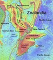
קובץ:Zealandia, topographic map.jpg
מראה

גודל התצוגה המקדימה הזאת: 529 × 600 פיקסלים. רזולוציות אחרות: 212 × 240 פיקסלים | 423 × 480 פיקסלים | 678 × 768 פיקסלים | 903 × 1,024 פיקסלים | 1,500 × 1,700 פיקסלים.
לקובץ המקורי (1,500 × 1,700 פיקסלים, גודל הקובץ: 4.57 מ"ב, סוג MIME: image/jpeg)
היסטוריית הקובץ
ניתן ללחוץ על תאריך/שעה כדי לראות את הקובץ כפי שנראה באותו זמן.
| תאריך/שעה | תמונה ממוזערת | ממדים | משתמש | הערה | |
|---|---|---|---|---|---|
| נוכחית | 18:55, 9 בפברואר 2019 |  | 1,700 × 1,500 (4.57 מ"ב) | Ulanwp | spelling of Bollons Seamount corrected |
| 22:43, 21 במרץ 2017 |  | 1,700 × 1,500 (4.57 מ"ב) | Ulanwp | Geographical Names inserted | |
| 21:59, 20 במרץ 2017 |  | 1,700 × 1,500 (4.44 מ"ב) | Ulanwp | {{Information |Description ={{en|1=Topographic map of Zealandia, based on bathmetry data from Scripps Institution of Oceanography, University of California, San Diego}} |Source =http://topex.ucsd.edu/WWW_html/mar_topo.html |Author =U... |
שימוש בקובץ
הדף הבא משתמש בקובץ הזה:
שימוש גלובלי בקובץ
אתרי הוויקי השונים הבאים משתמשים בקובץ זה:
- שימוש באתר ar.wikipedia.org
- שימוש באתר ast.wikipedia.org
- שימוש באתר bg.wikipedia.org
- שימוש באתר ca.wikipedia.org
- שימוש באתר ceb.wikipedia.org
- שימוש באתר de.wikipedia.org
- Lord Howe Rise
- Zealandia
- Gisborne-Erdbeben von 2007
- Geologie Neuseelands
- Geographie Neuseelands
- Chatham Rise
- Campbell Plateau
- Bounty Trough
- Norfolk Ridge
- New Caledonia Trough
- Challenger Plateau
- Geologie der Antarktischen Halbinsel
- Geologie Ostantarktikas
- Vulkanische Provinzen der Antarktischen Halbinsel
- שימוש באתר en.wikipedia.org
- Chatham Rise
- Lord Howe Rise
- South Tasman Rise
- Campbell Plateau
- Meiolania
- Challenger Plateau
- Norfolk Ridge
- Lord Howe Seamount Chain
- Zealandia
- Continent
- Submerged continent
- East Tasman Plateau
- Bollons Seamount
- Bounty Trough
- Tasmantid Seamount Chain
- Tasmantid hotspot
- Joseph Gilbert Seamount
- Gascoyne Seamount
- Geology of New Caledonia
- Taupo Bank
- Derwent Hunter Guyot
- Britannia Guyots
- Queensland Guyot
- Geology of Zealandia
- Three Kings Ridge
- שימוש באתר es.wikipedia.org
- שימוש באתר eu.wikipedia.org
- שימוש באתר fr.wikipedia.org

