
קובץ:WW2-Holocaust-ROstland.PNG
אין גרסה ברזולוציה גבוהה יותר.
WW2-Holocaust-ROstland.PNG (442 × 418 פיקסלים, גודל הקובץ: 145 ק"ב, סוג MIME: image/png)
| זהו קובץ שמקורו במיזם ויקישיתוף. תיאורו בדף תיאור הקובץ המקורי (בעברית) מוצג למטה. |
תקציר
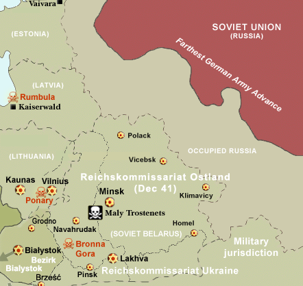
| תיאור |
Map of the Holocaust in Reichskommissariat Ostland (Belarus and the Baltic States) during World War II, 1939-1945. This map shows all extermination camps (or death camps), most major concentration camps, labor camps, prison camps, ghettos, major deportation routes and major massacre sites. Notes: 1. Extermination camps were dedicated death camps, but all camps and ghettos took a toll of many, many lives. 2. Concentration camps include labor camps, prison camps & transit camps. 3. Not all camps & ghettos are shown. 4. Borders are at the height of Axis domination (1942). 5. Some regions have German designations (e.g. "Ostland"), with the present country name denoted in uppercase letters in parenthesis below the German designation (e.g. "(AUSTRIA)"). 6. Present (2007) borders are dotted. |
| תאריך יצירה | (UTC) |
| מקור | |
| יוצר | |
| אישורים והיתרים (שימוש חוזר בקובץ זה) |
CC, see below. The map is completely unrestricted for any Wikipedia/Wikimedia project. |
| גרסאות אחרות |
 Derivative works of this file: WW2-Holocaust-Poland.PNGImage:WW2-Holocaust-Europe-2007Borders.png (present (2007) borders). If you have any opinions/suggestions, please contact me here on my talk page. |

|
יש ליצור מחדש את התמונה historical map הזו באמצעות גרפיקה וקטורית כדוגמת קובץ SVG. לפעולה זו מספר יתרונות, כפי שניתן לקרוא (באנגלית) בדף Commons:Media for cleanup. אם ברשותכם קובץ SVG, אנא העלו אותו. לאחר מכן, החליפו תבנית זו בתבנית
{{vector version available|שם הקובץ.svg}} |
רישיון
I, Dennis Nilsson, בעל זכויות היוצרים על היצירה הזאת, מפרסם אותה בזאת תחת הרישיון הבא:
הקובץ הזה מתפרסם לפי תנאי רישיון קריאייטיב קומונז ייחוס 3.0 לא מותאם.
ייחוס: I, Dennis Nilsson
- יש לך חופש:
- לשתף – להעתיק, להפיץ ולהעביר את העבודה
- לערבב בין עבודות – להתאים את העבודה
- תחת התנאים הבאים:
- ייחוס – יש לתת ייחוס הולם, לתת קישור לרישיון, ולציין אם נעשו שינויים. אפשר לעשות את זה בכל צורה סבירה, אבל לא בשום צורה שמשתמע ממנה שמעניק הרישיון תומך בך או בשימוש שלך.
- derivative work: Piotr Konieczny aka Prokonsul Piotrus Talk
|Permission= |other_versions= }}
| זוהי תמונה מרוטשת, זאת אומרת שהתמונה שונתה בצורה דיגיטלית מהמקור. Modifications: Belarus and Baltic States only. את התמונה המקורית ניתן לראות ב: WW2-Holocaust-Europe.png.
|
אני, בעל זכויות היוצרים על עבודה זו, מפרסם בזאת את העבודה תחת הרישיון הבא:
הקובץ הזה מתפרסם לפי תנאי רישיון קריאייטיב קומונז ייחוס 3.0 לא מותאם.
- יש לך חופש:
- לשתף – להעתיק, להפיץ ולהעביר את העבודה
- לערבב בין עבודות – להתאים את העבודה
- תחת התנאים הבאים:
- ייחוס – יש לתת ייחוס הולם, לתת קישור לרישיון, ולציין אם נעשו שינויים. אפשר לעשות את זה בכל צורה סבירה, אבל לא בשום צורה שמשתמע ממנה שמעניק הרישיון תומך בך או בשימוש שלך.
יומן העלאה מקורי
This image is a derivative work of the following images:
- File:WW2-Holocaust-Europe.png licensed with Cc-by-3.0
- 2007-12-20T03:41:38Z Dna-webmaster 1310x1090 (845818 Bytes) new version without "Axis cooperating" in legend
- 2007-12-20T02:00:30Z Dna-webmaster 1310x1090 (844034 Bytes) Now entire West Prussia and Wartheland is included in the Third Reich
- 2007-12-19T16:42:15Z Dna-webmaster 1310x1090 (847461 Bytes) still not Da Vinci, but errors have been corrected (Germany borders West/East), West & East Prussia borders/coloring and Poland General Government corrected borders.
- 2007-12-17T10:46:28Z Dna-webmaster 1310x1090 (844633 Bytes) new map with 1942 borders, not Da Vinci, but here it goes...
- 2007-10-19T13:32:25Z Dna-webmaster 1310x1090 (784727 Bytes) and another update
- 2007-10-19T12:21:52Z Dna-webmaster 1310x1090 (789383 Bytes) quick fix
- 2007-10-19T12:11:07Z Dna-webmaster 1310x1090 (789413 Bytes) {{Information |Description=Map of the Holocaust in Europe during World War II, 1939-1945. This map shows all extermination camps (or ''death camps''), most major concentration camps, work camps, prison camps, ghettos, major
Uploaded with derivativeFX' '
היסטוריית הקובץ
ניתן ללחוץ על תאריך/שעה כדי לראות את הקובץ כפי שנראה באותו זמן.
| תאריך/שעה | תמונה ממוזערת | ממדים | משתמש | הערה | |
|---|---|---|---|---|---|
| נוכחית | 19:51, 29 ביולי 2016 | | 418 × 442 (145 ק"ב) | Poeticbent | file reloaded, cache promblems |
| 19:44, 29 ביולי 2016 |  | 418 × 442 (145 ק"ב) | Poeticbent | missing elements including locations | |
| 22:25, 5 בספטמבר 2013 |  | 418 × 442 (131 ק"ב) | Poeticbent | most obvious error, Lithuania was never part of Reichskommissariat Ostland, neither was Bialystok, added names of major cities | |
| 21:44, 2 בנובמבר 2009 |  | 418 × 442 (90 ק"ב) | Flying Saucer | Vaivara | |
| 22:32, 19 בפברואר 2009 |  | 418 × 442 (90 ק"ב) | Piotrus | {{Information |Description=Map of the Holocaust in Reichskommissariat Ostland (Belarus and the Baltic States) during World War II, 1939-1945. <br> This map shows all extermination camps (or ''death camps''), most major concentration camps, labor camps, pr |
שימוש בקובץ
הדף הבא משתמש בקובץ הזה:
שימוש גלובלי בקובץ
אתרי הוויקי השונים הבאים משתמשים בקובץ זה:
- שימוש באתר be-tarask.wikipedia.org
- שימוש באתר ca.wikipedia.org
- שימוש באתר da.wikipedia.org
- שימוש באתר de.wikipedia.org
- שימוש באתר el.wikipedia.org
- שימוש באתר en.wikipedia.org
- שימוש באתר es.wikipedia.org
- שימוש באתר fa.wikipedia.org
- שימוש באתר fi.wikipedia.org
- שימוש באתר fr.wikipedia.org
- שימוש באתר fy.wikipedia.org
- שימוש באתר it.wikipedia.org
- שימוש באתר ja.wikipedia.org
- שימוש באתר mk.wikipedia.org
- שימוש באתר nl.wikipedia.org
- שימוש באתר no.wikipedia.org
- שימוש באתר pl.wikipedia.org
- שימוש באתר pt.wikipedia.org
- שימוש באתר ro.wikipedia.org
- שימוש באתר sr.wikipedia.org
- שימוש באתר sv.wikipedia.org
- שימוש באתר tr.wikipedia.org
- שימוש באתר vi.wikipedia.org
- שימוש באתר zh.wikipedia.org