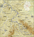
קובץ:Verlaufskarte Werra.png
מראה

גודל התצוגה המקדימה הזאת: 557 × 600 פיקסלים. רזולוציות אחרות: 223 × 240 פיקסלים | 446 × 480 פיקסלים | 713 × 768 פיקסלים | 951 × 1,024 פיקסלים | 1,393 × 1,500 פיקסלים.
לקובץ המקורי (1,393 × 1,500 פיקסלים, גודל הקובץ: 3.04 מ"ב, סוג MIME: image/png)
היסטוריית הקובץ
ניתן ללחוץ על תאריך/שעה כדי לראות את הקובץ כפי שנראה באותו זמן.
| תאריך/שעה | תמונה ממוזערת | ממדים | משתמש | הערה | |
|---|---|---|---|---|---|
| נוכחית | 10:40, 16 באוגוסט 2008 |  | 1,500 × 1,393 (3.04 מ"ב) | Lencer | {{Information |Description= |Source= |Date= |Author= |Permission= |other_versions= }} |
| 15:14, 12 באוגוסט 2008 |  | 1,500 × 1,393 (3.03 מ"ב) | Lencer | Kleinigkeit korrigiert | |
| 17:04, 9 באוגוסט 2008 |  | 1,500 × 1,393 (3.03 מ"ב) | Lencer | == Beschreibung == {{Information |Description=Die Werra und ihre Nebenflüsse |Source=own work, used: * http://www.openstreetmap.org * [http://www2.demis.nl/wms/mapclip.htm Demis Webserver] * Generic Mapping Tools |Date=August 2008 |Author=[ |
שימוש בקובץ
הדף הבא משתמש בקובץ הזה:
שימוש גלובלי בקובץ
אתרי הוויקי השונים הבאים משתמשים בקובץ זה:
- שימוש באתר azb.wikipedia.org
- שימוש באתר br.wikipedia.org
- שימוש באתר cs.wikipedia.org
- שימוש באתר da.wikipedia.org
- שימוש באתר de.wikipedia.org
- שימוש באתר de.wikivoyage.org
- שימוש באתר en.wikipedia.org
- שימוש באתר es.wikipedia.org
- שימוש באתר fi.wikipedia.org
- שימוש באתר fr.wikipedia.org
- שימוש באתר hr.wikipedia.org
- שימוש באתר hu.wikipedia.org
- שימוש באתר it.wikipedia.org
- שימוש באתר ja.wikipedia.org
- שימוש באתר ko.wikipedia.org
- שימוש באתר lt.wikipedia.org
- שימוש באתר mk.wikipedia.org
- שימוש באתר nl.wikipedia.org
- שימוש באתר no.wikipedia.org
- שימוש באתר pl.wiktionary.org
- שימוש באתר pt.wikipedia.org
- שימוש באתר ro.wikipedia.org
- שימוש באתר ru.wikipedia.org
- שימוש באתר simple.wikipedia.org
- שימוש באתר sl.wikipedia.org
- שימוש באתר sr.wikipedia.org
- שימוש באתר sv.wikipedia.org
- שימוש באתר uk.wikipedia.org
- שימוש באתר www.wikidata.org

