לדלג לתוכן

קובץ:Tabaqah assad.jpg

תוכן הדף אינו נתמך בשפות אחרות.
מתוך ויקיפדיה, האנציקלופדיה החופשית

לקובץ המקורי (631 × 639 פיקסלים, גודל הקובץ: 236 ק"ב, סוג MIME‏: image/jpeg)

ויקישיתוף זהו קובץ שמקורו במיזם ויקישיתוף. תיאורו בדף תיאור הקובץ המקורי (בעברית) מוצג למטה.

תקציר

תיאור

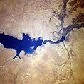
سد الفرات وبحيرة الأسد من الفضاء كانون الثاني 1996

English: Completed in 1973, the Tabaqah Dam (center of image) on the Euphrates River can be seen in this near-nadir view. The Tabaqah Dam is an earth filled dam nearly 197 feet (60 meters) high and 3 miles (5 km) long. The dam holds the waters of Lake Assad (center to left center of the image), a 50-mile (80 km) long and 5-mile (8 km) wide reservoir. Lake Assad and the Tabaqah Dam have not only provided increased hydroelectric power but the lake has doubled Syria’s irrigated land. Actual crop production has not reached the goals set by the Syrian government due to a number of problems including the gypsum subsoil of the region, and whether or not farmers could be attracted back to this scarsely populated area from urban areas or more crowded agricultural areas in other parts of the country. Also the water levels within Lake Assad remain low due mostly in part to construction of the Keban and Ataturk Dams in Turkey, which have reduced the water flow of the Euphrates River in Syria.
תאריך יצירה
מקור http://eol.jsc.nasa.gov/sseop/EFS/photoinfo.pl?PHOTO=STS078-740-83 , http://upload.wikimedia.org/wikipedia/en/c/cf/Tabaqah_assad.jpg
יוצר NASA
This image or video was catalogued by one of the centers of the United States National Aeronautics and Space Administration (NASA) under Photo ID: STS078-740-83.

This tag does not indicate the copyright status of the attached work. A normal copyright tag is still required. See Commons:Licensing.
Other languages:

רישיון

Public domain קובץ זה נמצא ברשות הציבור מכיוון שהוא נוצר על ידי נאס"א. מדיניות זכויות היוצרים של נאס"א קובעת ש"חומרים של NASA אינם מוגנים בזכויות יוצרים אלא אם צוין אחרת". (דף מדיניות זכויות היוצרים ב-NASA או מדיניות שימוש בתמונות ב-JPL).
אזהרות:
  • שימוש בלוגואים, סמלים וטלאים של נאס"א כפוף להגבלה של החוק בארצות הברית 14 CFR 1221.
  • אתר האינטרנט של נאס"א מכיל תמונות רבות שמקורן מתוכנית החלל הסובייטית/סוכנות החלל הרוסית, וחומרים נוספים של סוכנויות חלל אחרות. קבצים אלו אינם בהכרח תחת רשות הציבור.
  • חומרים מטלסקופ החלל האבל עשויים להיות מוגנים בזכויות יוצרים אם לא מצוין במפורש שהגיעו מSTScI. [1]
  • כל החומרים שנוצרו על ידי חללית SOHO מוגנים בזכויות יוצרים ודורשים הרשאה עבור שימוש מסחרי לא חינוכי. [2]
  • תמונות המוצגות באתר Astronomy Picture of the Day (APOD) עשויים להיות מוגנים בזכויות יוצרים. [3]

כיתובים

נא להוסיף משפט שמסביר מה הקובץ מייצג

פריטים שמוצגים בקובץ הזה

מוצג

Baath Dam אנגלית

היסטוריית הקובץ

ניתן ללחוץ על תאריך/שעה כדי לראות את הקובץ כפי שנראה באותו זמן.

תאריך/שעהתמונה ממוזערתממדיםמשתמשהערה
נוכחית10:45, 3 בפברואר 2010תמונה ממוזערת לגרסה מ־10:45, 3 בפברואר 2010‪639 × 631‬ (236 ק"ב)RehmanFlipped to align according to directions
23:09, 28 באוקטובר 2007תמונה ממוזערת לגרסה מ־23:09, 28 באוקטובר 2007‪639 × 631‬ (200 ק"ב)Amir syria{{Information |Description=سد الفرات |Source=http://eol.jsc.nasa.gov/sseop/EFS/photoinfo.pl?PHOTO=STS078-740-83 , http://upload.wikimedia.org/wikipedia/en/c/cf/Tabaqah_assad.jpg |Date= |Author= |Permission= |other_versions= }}

הדף הבא משתמש בקובץ הזה:

שימוש גלובלי בקובץ

אתרי הוויקי השונים הבאים משתמשים בקובץ זה:

צפו בשימושים בקובץ זה במיזמי ויקימדיה נוספים.

מטא־נתונים