
קובץ:Seven second summits map-fr.svg

גודל התצוגה המקדימה הזאת מסוג PNG של קובץ ה־SVG הזה: 800 × 406 פיקסלים. רזולוציות אחרות: 320 × 163 פיקסלים | 640 × 325 פיקסלים | 1,024 × 520 פיקסלים | 1,280 × 650 פיקסלים | 2,560 × 1,300 פיקסלים | 1,636 × 831 פיקסלים.
לקובץ המקורי (קובץ SVG, הגודל המקורי: 1,636 × 831 פיקסלים, גודל הקובץ: 4.11 מ"ב)
| זהו קובץ שמקורו במיזם ויקישיתוף. תיאורו בדף תיאור הקובץ המקורי (בעברית) מוצג למטה. |
תקציר
| תיאור |
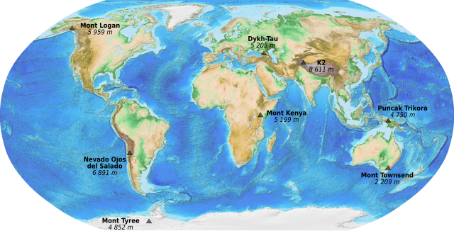
English: Map of the Seven Second Summits. French version.
Français : Carte des Sept seconds sommets (secondes plus hautes montagnes de chaque continent). |
||
| תאריך יצירה | (UTC) | ||
| מקור |
|
||
| יוצר | Sémhur (talk) | ||
| גרסאות אחרות | |||
| ייחוס (required by the license) | © Sémhur / Wikimedia Commons / | ||
| SVG | W3C-validity not checked. . Inkscape עם נוצרה ה …important
|
||
| Graphic Lab |

רישיון
This image is in the public domain because it contains materials that originally came from the U.S. National Oceanic and Atmospheric Administration, taken or made as part of an employee's official duties.
|
היסטוריית הקובץ
ניתן ללחוץ על תאריך/שעה כדי לראות את הקובץ כפי שנראה באותו זמן.
| תאריך/שעה | תמונה ממוזערת | ממדים | משתמש | הערה | |
|---|---|---|---|---|---|
| נוכחית | 00:28, 23 באוקטובר 2010 | | 831 × 1,636 (4.11 מ"ב) | Sémhur | == {{int:filedesc}} == {{Information |Description={{en|1=Map of the Seven Second Summits. French version.}} {{fr|1=Carte des Sept seconds sommets (secondes plus hautes montagnes de chaque continent |
שימוש בקובץ
הדף הבא משתמש בקובץ הזה:
שימוש גלובלי בקובץ
אתרי הוויקי השונים הבאים משתמשים בקובץ זה:
- שימוש באתר ca.wikipedia.org
- שימוש באתר en.wikipedia.org
- שימוש באתר es.wikipedia.org
- שימוש באתר fa.wikipedia.org
- שימוש באתר fr.wikipedia.org
- שימוש באתר ja.wikipedia.org
- שימוש באתר nn.wikipedia.org
- שימוש באתר pt.wikipedia.org
- שימוש באתר sl.wikipedia.org
- שימוש באתר uk.wikipedia.org
- שימוש באתר www.wikidata.org