לדלג לתוכן

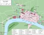
קובץ:London 1300 Historical Atlas William R Shepherd (died 1934).PNG

תוכן הדף אינו נתמך בשפות אחרות.
מתוך ויקיפדיה, האנציקלופדיה החופשית

London_1300_Historical_Atlas_William_R_Shepherd_(died_1934).PNG(700 × 536 פיקסלים, גודל הקובץ: 644 ק"ב, סוג MIME‏: image/png)

ויקישיתוף זהו קובץ שמקורו במיזם ויקישיתוף. תיאורו בדף תיאור הקובץ המקורי (בעברית) מוצג למטה.
קובץ זה הוחלף על ידי הקובץ File:Plan of London in 1300.jpg. מומלץ להשתמש בקובץ החדש.
new file
קיימת תמונה חדשה תמונה זו בגרסה וקטורית בפורמט "SVG". יש להחליף את התמונה הנוכחית בתמונה החדשה.

File:London 1300 Historical Atlas William R Shepherd (died 1934).PNG → File:Map of London, 1300.svg


בשפות אחרות
Alemannisch  Bahasa Indonesia  Bahasa Melayu  British English  català  čeština  dansk  Deutsch  eesti  English  español  Esperanto  euskara  français  Frysk  galego  hrvatski  Ido  italiano  lietuvių  magyar  Nederlands  norsk bokmål  norsk nynorsk  occitan  Plattdüütsch  polski  português  português do Brasil  română  Scots  sicilianu  slovenčina  slovenščina  suomi  svenska  Tiếng Việt  Türkçe  vèneto  Ελληνικά  беларуская (тарашкевіца)  български  македонски  нохчийн  русский  српски / srpski  татарча/tatarça  українська  ქართული  հայերեն  বাংলা  தமிழ்  മലയാളം  ไทย  한국어  日本語  简体中文  繁體中文  עברית  العربية  فارسی  +/−
New SVG image

Source: en:Image:London 1300 Historical Atlas William R Shepherd (died 1934).PNG, 03:43, 14 May 2005 . . CalJW (Talk) . . 700x536 (659,361 bytes) (A map of London in 1300 from a historical atlas by William R Shepherd. Apart from religious foundations and two or three other complexes, the city is confined within its walls, which are well inside the present boundary of the City of London. The City)

English: A map of London in 1300 from a historical atlas by William R Shepherd. Apart from religious foundations and two or three other complexes, the city is confined within its walls, which are well inside the present boundary of the City of London. The City is flanked to the east and west by the royal fortress of the Tower of London and the royal palace of Bridewell. The route from the city to the royal centre of Westminster is not yet fully built up. There is a settlement at Southwark, but it is very small.


Public domain
יצירה זו נמצאת בנחלת הכלל במדינת המקור ובמדינות אחרות בהם תקופת זכויות היוצרים היא משך חיי היוצר ו-70 שנה (או פחות) מפטירתו.

You must also include a United States public domain tag to indicate why this work is in the public domain in the United States.

כיתובים

נא להוסיף משפט שמסביר מה הקובץ מייצג

פריטים שמוצגים בקובץ הזה

מוצג

היסטוריית הקובץ

ניתן ללחוץ על תאריך/שעה כדי לראות את הקובץ כפי שנראה באותו זמן.

תאריך/שעהתמונה ממוזערתממדיםמשתמשהערה
נוכחית21:20, 20 במאי 2006תמונה ממוזערת לגרסה מ־21:20, 20 במאי 2006‪536 × 700‬ (644 ק"ב)SiebrandHigher resolution from source
10:59, 25 באוקטובר 2005תמונה ממוזערת לגרסה מ־10:59, 25 באוקטובר 2005‪229 × 299‬ (134 ק"ב)JaT~commonswikiMap of London 1300

הדף הבא משתמש בקובץ הזה:

שימוש גלובלי בקובץ

אתרי הוויקי השונים הבאים משתמשים בקובץ זה:

מטא־נתונים