
קובץ:French Algeria evolution 1830-1962 map-fr.svg

גודל התצוגה המקדימה הזאת מסוג PNG של קובץ ה־SVG הזה: 604 × 600 פיקסלים. רזולוציות אחרות: 242 × 240 פיקסלים | 483 × 480 פיקסלים | 773 × 768 פיקסלים | 1,031 × 1,024 פיקסלים | 2,062 × 2,048 פיקסלים | 1,287 × 1,278 פיקסלים.
לקובץ המקורי (קובץ SVG, הגודל המקורי: 1,287 × 1,278 פיקסלים, גודל הקובץ: 1.86 מ"ב)
| זהו קובץ שמקורו במיזם ויקישיתוף. תיאורו בדף תיאור הקובץ המקורי (בעברית) מוצג למטה. |
תקציר
| תיאור |
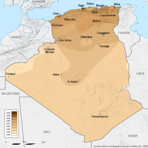
English: French Algeria evolution map, from 1830 to 1962.
Français : Carte montrant l'évolution territoriale de l'Algérie française, de 1830 à 1962.
|
| תאריך יצירה | (UTC) |
| מקור |
English:
Français :
|
| יוצר | Sémhur |
| גרסאות אחרות |
Derivative works of this file: French Algeria evolution 1830-1962 map-es.svg |
| ייחוס (required by the license) | © Sémhur / Wikimedia Commons / |
| SVGהתפתחות |
| מיקום המצלמה | | תמונה זו ותמונות נוספות במיקום: OpenStreetMap |
|---|
רישיון
אני, בעל זכויות היוצרים על היצירה הזאת, מפרסם אותה בזאת תחת הרישיונות הבאים:
| יוצרים זכויות (copyleft): יצירת האמנות הזאת חופשית; מותר לך להפיץ אותה או לשנות לפי תנאי רישיון אמנות חופשית (Free Art License). אפשר למצוא עותק של הרישיון הזה באתר Copyleft Attitude כמו גם באתרים אחרים. |
הקובץ הזה מתפרסם לפי תנאי רישיונות קריאייטיב קומונז ייחוס–שיתוף זהה 4.0 בין־לאומי, 3.0 לא מותאם, 2.5 כללי, 2.0 כללי ו־1.0 Generic.
- הנכם רשאים:
- לשתף – להעתיק, להפיץ ולהעביר את העבודה
- לערבב בין עבודות – להתאים את העבודה
- תחת התנאים הבאים:
- ייחוס – יש לתת ייחוס הולם, לתת קישור לרישיון, ולציין אם נעשו שינויים. אפשר לעשות את זה בכל צורה סבירה, אבל לא בשום צורה שמשתמע ממנה שמעניק הרישיון תומך בך או בשימוש שלך.
- שיתוף זהה – אם תיצרו רמיקס, תשנו, או תבנו על החומר, חובה עליכם להפיץ את התרומות שלך לפי תנאי רישיון זהה או תואם למקור.
הנכם מוזמנים לבחור את הרישיון הרצוי בעיניכם.
יומן העלאה מקורי
This image is a derivative work of the following images:
- File:Algeria_location_map.svg licensed with Cc-by-sa-3.0, GFDL
- 2009-11-17T12:51:26Z Sting 1287x1278 (372657 Bytes) == {{int:filedesc}} == {{Location|28|19|00|N|1|39|00|E|scale:8000000}} {{Information |Description={{en|Blank administrative map of [[:en:Algeria|Algeria]], for geo-location purposes.}} {{fr|Carte administrative vierge de l'[
Uploaded with derivativeFX
היסטוריית הקובץ
ניתן ללחוץ על תאריך/שעה כדי לראות את הקובץ כפי שנראה באותו זמן.
| תאריך/שעה | תמונה ממוזערת | ממדים | משתמש | הערה | |
|---|---|---|---|---|---|
| נוכחית | 22:34, 22 במאי 2014 | | 1,278 × 1,287 (1.86 מ"ב) | Sémhur | Valid SVG |
| 21:57, 29 בספטמבר 2012 |  | 1,278 × 1,287 (1.86 מ"ב) | Sémhur | == {{int:filedesc}} == {{Information |Description={{Multilingual description |en= en:French Algeria evolution map, from 1830 to 1962. |fr= Carte de l'fr:Algérie française, de 1830 à 1962. }} <br/> Scale: 1:6,800,000 (precision: 1,700 m)... |
שימוש בקובץ
הדפים הבאים משתמשים בקובץ הזה:
שימוש גלובלי בקובץ
אתרי הוויקי השונים הבאים משתמשים בקובץ זה:
- שימוש באתר ast.wikipedia.org
- שימוש באתר bg.wikipedia.org
- שימוש באתר ca.wikipedia.org
- שימוש באתר da.wikipedia.org
- שימוש באתר de.wikipedia.org
- שימוש באתר en.wikipedia.org
- שימוש באתר eu.wikipedia.org
- שימוש באתר fa.wikipedia.org
- שימוש באתר fi.wikipedia.org
- שימוש באתר fr.wikipedia.org
- שימוש באתר ga.wikipedia.org
- שימוש באתר hy.wikipedia.org
- שימוש באתר id.wikipedia.org
- שימוש באתר it.wikipedia.org
- שימוש באתר ja.wikipedia.org
- שימוש באתר ka.wikipedia.org
- שימוש באתר ko.wikipedia.org
- שימוש באתר lt.wikipedia.org
- שימוש באתר lv.wikipedia.org
- שימוש באתר mk.wikipedia.org
- שימוש באתר ms.wikipedia.org
- שימוש באתר mt.wikipedia.org
- שימוש באתר nl.wikipedia.org
- שימוש באתר pl.wikipedia.org
- שימוש באתר pnb.wikipedia.org
- שימוש באתר pt.wikipedia.org