
קובץ:Congo regions named.png
אין גרסה ברזולוציה גבוהה יותר.
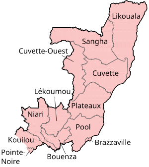
Congo_regions_named.png (300 × 337 פיקסלים, גודל הקובץ: 14 ק"ב, סוג MIME: image/png)
| זהו קובץ שמקורו במיזם ויקישיתוף. תיאורו בדף תיאור הקובץ המקורי (בעברית) מוצג למטה. |
| תיאור |
Map of the regions of the Republic of the Congo, named in French (local language), mostly compatible with English. The individual maps are: |
| תאריך יצירה | |
| מקור | Self-made, traced from public domain UN or CIA maps. |
| יוצר | User:Golbez |
| אישורים והיתרים (שימוש חוזר בקובץ זה) |
Provide attribution, please. See below. |
אני, בעל זכויות היוצרים על היצירה הזאת, מפרסם אותה בזאת תחת הרישיונות הבאים:
- הנכם רשאים:
- לשתף – להעתיק, להפיץ ולהעביר את העבודה
- לערבב בין עבודות – להתאים את העבודה
- תחת התנאים הבאים:
- ייחוס – יש לתת ייחוס הולם, לתת קישור לרישיון, ולציין אם נעשו שינויים. אפשר לעשות את זה בכל צורה סבירה, אבל לא בשום צורה שמשתמע ממנה שמעניק הרישיון תומך בך או בשימוש שלך.
- שיתוף זהה – אם תיצרו רמיקס, תשנו, או תבנו על החומר, חובה עליכם להפיץ את התרומות שלך לפי תנאי רישיון זהה או תואם למקור.

|
מוענקת בכך הרשות להעתיק, להפיץ או לשנות את המסמך הזה, לפי תנאי הרישיון לשימוש חופשי במסמכים של גנו, גרסה 1.2 או כל גרסה מאוחרת יותר שתפורסם על־ידי המוסד לתוכנה חופשית; ללא פרקים קבועים, ללא טקסט עטיפה קדמית וללא טקסט עטיפה אחורית. עותק של הרישיון כלול בפרק שכותרתו הרישיון לשימוש חופשי במסמכים של גנו. |
| הקובץ הזה מתפרסם לפי תנאי רישיון קריאייטיב קומונז ייחוס-שיתוף זהה 3.0 לא מותאם. | ||
| ||
| תבנית רישוי זו הוספה לקובץ כחלק מעדכון רישיון GFDL. |
הנכם מוזמנים לבחור את הרישיון הרצוי בעיניכם.
היסטוריית הקובץ
ניתן ללחוץ על תאריך/שעה כדי לראות את הקובץ כפי שנראה באותו זמן.
| תאריך/שעה | תמונה ממוזערת | ממדים | משתמש | הערה | |
|---|---|---|---|---|---|
| נוכחית | 20:29, 1 באוקטובר 2023 | | 337 × 300 (14 ק"ב) | Yunan973 | fix all boundaries according to last offical maps (2023) |
| 19:53, 28 בדצמבר 2004 |  | 370 × 300 (13 ק"ב) | Golbez | Map of the regions of the Republic of the Congo. Made by User:Golbez. {{cc-by-sa-2.0}} |
שימוש בקובץ
הדף הבא משתמש בקובץ הזה:
שימוש גלובלי בקובץ
אתרי הוויקי השונים הבאים משתמשים בקובץ זה:
- שימוש באתר ast.wikipedia.org
- שימוש באתר avk.wikipedia.org
- שימוש באתר be-tarask.wikipedia.org
- שימוש באתר bg.wikipedia.org
- שימוש באתר bn.wikipedia.org
- שימוש באתר br.wikipedia.org
- שימוש באתר ca.wikipedia.org
- שימוש באתר de.wikipedia.org
- שימוש באתר el.wikipedia.org
- שימוש באתר en.wikipedia.org
- Departments of the Republic of the Congo
- Pointe-Noire
- Districts of the Republic of the Congo
- User:Jonny-mt/Gallery of current first-level administrative country subdivisions maps
- Kimongo District
- Mayoko District
- Divénié District
- Louvakou District
- Template:Districts of the Republic of the Congo
- User talk:Markussep/Archive 4
- Kibangou District
- Moutamba District
- Boko-Songho District
- Loudima District
- Madingou District
- Mfouati District
- Mouyondzi District
- Kayes District
- Boundji District
- Loukela District
- Makoua District
- Mossaka District
- Okoyo District
- Oyo District
- Ewo District
- Kelle District
- Mbomo District
- Kakamoeka District
- Madingo-Kayes District
- Mvouti District
- Bambama District
- Komono District
- Sibiti District
- Zanaga District
- Dongou District
- Epena District
- Impfondo District