
קובץ:Babylon 1829 cropped.gif
אין גרסה ברזולוציה גבוהה יותר.
Babylon_1829_cropped.gif (489 × 356 פיקסלים, גודל הקובץ: 75 ק"ב, סוג MIME: image/gif)
| זהו קובץ שמקורו במיזם ויקישיתוף. תיאורו בדף תיאור הקובץ המקורי (בעברית) מוצג למטה. |
| תיאור |
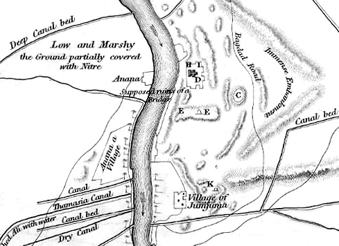
English: Map of the site of Babylon prior to its excavation later in the 19th century. |
| תאריך יצירה | (UTC) |
| מקור |
|
| יוצר |
|
| זוהי תמונה מרוטשת, זאת אומרת שהתמונה שונתה בצורה דיגיטלית מהמקור. Modifications: Cropped to show southern area, highlighting the Jumjuma mound. את התמונה המקורית ניתן לראות ב: Babylon 1829.jpg. השינוי בוצע על ידי ChrisO.
|
|
יצירה זו נמצאת בנחלת הכלל במדינת המקור ובמדינות אחרות בהם תקופת זכויות היוצרים היא משך חיי היוצר ו-70 שנה (או פחות) מפטירתו.
| |
| הקובץ הזה זוהה כקובץ חופשי מכל מגבלה ידועה תחת חוק זכויות היוצרים, כולל כל הזכויות הקשורות והסמוכות. | |
יומן העלאה מקורי
This image is a derivative work of the following images:
- File:Babylon_1829.jpg licensed with PD-old
- 2010-06-06T22:50:24Z ChrisO 1065x1464 (228517 Bytes) {{Information |Description={{en|1=Map of the site of Babylon prior to its excavation later in the 19th century.}} |Source=Ground Plan of the Remains at & near Babylon |Author=Captain R. Mignan |Date=October 1829 |Permission=
Uploaded with derivativeFX
היסטוריית הקובץ
ניתן ללחוץ על תאריך/שעה כדי לראות את הקובץ כפי שנראה באותו זמן.
| תאריך/שעה | תמונה ממוזערת | ממדים | משתמש | הערה | |
|---|---|---|---|---|---|
| נוכחית | 23:56, 16 ביוני 2010 | | 356 × 489 (75 ק"ב) | ChrisO | |
| 02:07, 7 ביוני 2010 |  | 356 × 489 (88 ק"ב) | ChrisO | {{Information |Description={{en|1=Map of the site of Babylon prior to its excavation later in the 19th century.}} |Source=*File:Babylon_1829.jpg |Date=2010-06-06 23:07 (UTC) |Author=*File:Babylon_1829.jpg: Captain R. Mignan *derivative work: ~ |
שימוש בקובץ
הדף הבא משתמש בקובץ הזה:
שימוש גלובלי בקובץ
אתרי הוויקי השונים הבאים משתמשים בקובץ זה:
- שימוש באתר ar.wikipedia.org
- שימוש באתר bn.wikipedia.org
- שימוש באתר en.wikipedia.org
- שימוש באתר es.wikipedia.org
- שימוש באתר fa.wikipedia.org
- שימוש באתר fr.wikipedia.org
- שימוש באתר hyw.wikipedia.org
- שימוש באתר no.wikipedia.org
- שימוש באתר uk.wikipedia.org