
קובץ:Administrative divisions of Germany.svg

גודל התצוגה המקדימה הזאת מסוג PNG של קובץ ה־SVG הזה: 800 × 400 פיקסלים. רזולוציות אחרות: 320 × 160 פיקסלים | 640 × 320 פיקסלים | 1,024 × 512 פיקסלים | 1,280 × 641 פיקסלים | 2,560 × 1,281 פיקסלים | 1,037 × 519 פיקסלים.
לקובץ המקורי (קובץ SVG, הגודל המקורי: 1,037 × 519 פיקסלים, גודל הקובץ: 931 ק"ב)
| זהו קובץ שמקורו במיזם ויקישיתוף. תיאורו בדף תיאור הקובץ המקורי (בעברית) מוצג למטה. |
תקציר
| תיאור |
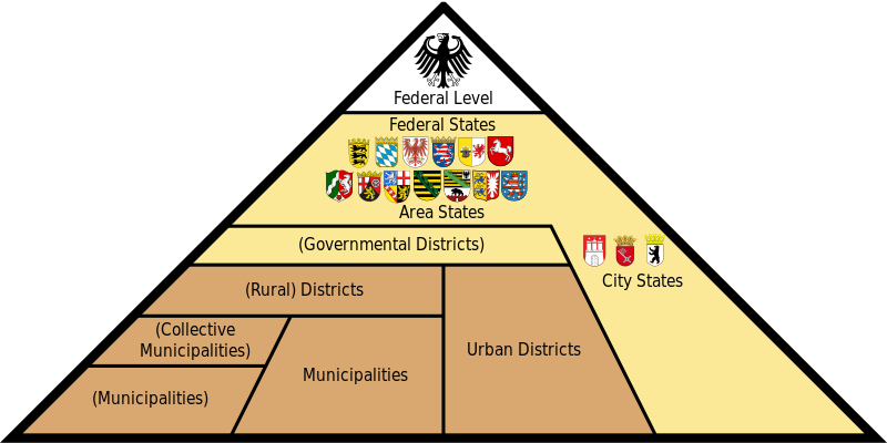
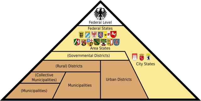
English: Graphic with the administrative division of the Federal Republic of Germany, showing the vertical (Federal) separation of powers across the federal government (White), the states (Yellow), and the municipalities (Brown).
Беларуская: Дыяграма адміністрацыйнага падзелу Федэральнай Рэспублікі Германія, якая адлюстроўвае вертыкальнае (федэральнае) падзяленне ўладаў паміж федэральным урадам (белы), землямі (жоўты) і акругамі (карычневы).
Deutsch: Grafik mit der Verwaltungsgliederung der Bundesrepublik Deutschland. Bundesebene (Weiß), Landesebene (Gelb), Kommunalebene (Braun). Schema des dreistufigen Verwaltungsaufbaus in den Flächenländern. Die allgemeine Verwaltung (1. Stufe) ist braun, die Sonderbehörden (2. und 3. Stufe) sind beige dargestellt.
Italiano: Grafico con la divisione amministrativa della Repubblica Federale di Germania, che mostra la separazione verticale dei poteri nel governo a livello federale (Bianco), degli stati (Giallo) e dei comuni (Marrone). Schema della struttura amministrativa a tre stadi negli stati non urbani. L'amministrazione generale (primo livello) è mostrata in marrone, le autorità speciali (secondo e terzo livello) sono mostrate in giallo.
Español: Gráfico con la división administrativa de la República Federal de Alemania, que muestra la separación vertical de poderes en el gobierno a nivel federal (Blanco), los estados (Amarillo) y los municipios (Marrón). Esquema de la estructura administrativa de tres etapas en los estados no urbanos. La administración general (primer nivel) se muestra en marrón, las autoridades especiales (segundo y tercer nivel) se muestran en amarillo.
Български: Графика на вертикалното административно деление на Федерална република Германия. Федерално ниво (бяло), провинциално ниво (жълто), местно ниво (кафяво). Схема на трите нива на административно устройство в териториалните провинции. Общата администрация (1-то ниво) е изобразено в кафяво, а специалните институции (2-ро и 3-то ниво) в бежаво.
Română: Diagramă cu diviziunea administrativă a Republicii Federale Germania.
Nederlands: Grafiek met de administratieve afdeling van de Bondsrepubliek Duitsland.
Português: Carta com a divisão administrativa da República Federal da Alemanha.
Plattdüütsch: So is de Verwalten in Düütschland vun ünnen na boven upboot.
Українська: Адміністративний устрій Федеративної Республіки Німеччини всіх рівнів
Čeština: Schema administrativního dělení Německa
Русский: Административное устройство Федеративной Республики Германия всех уровней
中文(中国大陆):德国行政区划
العربية: التقسيم الإداري في جمهورية ألمانيا الاتحادية
한국어: 독일 행정구역체계
日本語: ドイツの地方行政
Lëtzebuergesch: Vertikal Verwaltungsstruktur vun Däitschland |
| תאריך יצירה | |
| מקור |
נוצר על־ידי מעלה היצירה קובץ זה הוא יצירה נגזרת של :
|
| יוצר | Fred the Oyster (EN), Plaga med (BE), glglgl (original SVG), David Liuzzo (original PNG), C.Löser (content for PNG), Gzhegozh (UK), Roman Poulvas (RU), Poux (FR), JAn Dudík (CS), Soued031 (LB), Trygve W Nodeland (NO), Civvi (IT), R4m.3sp4d4s (ES), Andrew Dalby (LA), Salamander724 (KO), UkainoADX (JA), Nico (DA), Angel Miklashevsky (BG), Aeroid (merged SVG) |
| אישורים והיתרים (שימוש חוזר בקובץ זה) |
הקובץ הזה מתפרסם לפי תנאי רישיון קריאייטיב קומונז ייחוס-שיתוף זהה 2.0 גרמניה.
 |
| גרסאות אחרות |
Imagemaps: To be merged:
|
| SVGהתפתחות | Other tools עם נוצרה ה גרפיקה וקטורית This map is translated using SVG switch elements: all translations are stored in the same file. |


.svg)
.svg)
היסטוריית הקובץ
ניתן ללחוץ על תאריך/שעה כדי לראות את הקובץ כפי שנראה באותו זמן.
| תאריך/שעה | תמונה ממוזערת | ממדים | משתמש | הערה | |
|---|---|---|---|---|---|
| נוכחית | 05:43, 10 במאי 2024 | | 519 × 1,037 (931 ק"ב) | Jeffrey Kim | File uploaded using svgtranslate tool (https://svgtranslate.toolforge.org/). Added translation for yue. |
| 20:50, 31 במרץ 2024 |  | 519 × 1,037 (929 ק"ב) | Mrmw | cleaned code and prettified switch-block | |
| 01:36, 6 במרץ 2024 |  | 519 × 1,037 (1.29 מ"ב) | Plaga med | add Belarusian l10n | |
| 19:53, 27 במאי 2022 |  | 519 × 1,037 (1.29 מ"ב) | Liglioto | Final, revised translation of administrative terms. | |
| 10:34, 27 במאי 2022 |  | 519 × 1,037 (1.29 מ"ב) | Liglioto | Bulgarian translation revised. Administrative terms corrected in accordance with official translations of multilingual EU documents consulted on www.linguee.com | |
| 19:23, 25 במאי 2022 |  | 519 × 1,037 (1.29 מ"ב) | Liglioto | Adjusted positions of text fields | |
| 19:05, 25 במאי 2022 |  | 519 × 1,037 (1.29 מ"ב) | Liglioto | Translation into Bulgarian | |
| 19:00, 25 במאי 2022 |  | 519 × 1,037 (1.29 מ"ב) | Liglioto | Reverted to version as of 17:41, 4 December 2021 (UTC); mismatch of text fields | |
| 18:26, 25 במאי 2022 |  | 519 × 1,037 (1.29 מ"ב) | Liglioto | Added translation into Bulgarian language. | |
| 20:41, 4 בדצמבר 2021 |  | 519 × 1,037 (1.29 מ"ב) | Aeroid | SVG 1.1 // Editing SVG source code using c:User:Rillke/SVGedit.js |
שימוש בקובץ
הדף הבא משתמש בקובץ הזה:
שימוש גלובלי בקובץ
אתרי הוויקי השונים הבאים משתמשים בקובץ זה:
- שימוש באתר als.wikipedia.org
- שימוש באתר an.wikipedia.org
- שימוש באתר ar.wikipedia.org
- שימוש באתר ast.wikipedia.org
- שימוש באתר az.wikipedia.org
- שימוש באתר be.wikipedia.org
- שימוש באתר bg.wikipedia.org
- שימוש באתר bn.wikipedia.org
- שימוש באתר bxr.wikipedia.org
- שימוש באתר cs.wikipedia.org
- שימוש באתר cv.wikipedia.org
- שימוש באתר da.wikipedia.org
- שימוש באתר de.wikipedia.org
- Kreisfreie Stadt
- Gewaltenteilung
- Oberbürgermeister
- Regierungsbezirk
- Stadtstaat
- Kommunalpolitik in Deutschland
- Amt (Kommunalrecht)
- Gemeinde (Deutschland)
- Kommunalrecht (Deutschland)
- Politisches System der Bundesrepublik Deutschland
- Bundesebene (Deutschland)
- Öffentliche Verwaltung
- Föderalismus in Deutschland
- Diskussion:Gemeinde (Deutschland)
- Gemeinde
- Vorkonstitutionelles Recht
- Deutschland
- Benutzer:Gbeckmann
- Verwaltungskooperation in Deutschland
- Verwaltungsgliederung Deutschlands
- Benutzer:Hopfenbart
- Vorlage:Verwaltungsgliederung Deutschlands