
קובץ:1771 Bonne Map of the Guinea Coast of West Africa and the Cape Verde Islands - Geographicus - Guinea-bonne-1771.jpg

גודל התצוגה המקדימה הזאת: 439 × 599 פיקסלים. רזולוציות אחרות: 176 × 240 פיקסלים | 352 × 480 פיקסלים | 563 × 768 פיקסלים | 751 × 1,024 פיקסלים | 1,502 × 2,048 פיקסלים | 2,933 × 4,000 פיקסלים.
לקובץ המקורי (2,933 × 4,000 פיקסלים, גודל הקובץ: 2.29 מ"ב, סוג MIME: image/jpeg)
| זהו קובץ שמקורו במיזם ויקישיתוף. תיאורו בדף תיאור הקובץ המקורי (בעברית) מוצג למטה. |
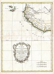
| Rigobert Bonne: Carte de la Guinee contenant les Isles du Cap Verd, le Senegal, la Cote de Guinee proprement dite, les Royaumes de Loango, Congo, Angola, et Benguela avec les Pays voisins autant qu'ils sont connus.
( |
|||||||||||||||||||||||
|---|---|---|---|---|---|---|---|---|---|---|---|---|---|---|---|---|---|---|---|---|---|---|---|
| אומן |
|
||||||||||||||||||||||
| כותרת |
Carte de la Guinee contenant les Isles du Cap Verd, le Senegal, la Cote de Guinee proprement dite, les Royaumes de Loango, Congo, Angola, et Benguela avec les Pays voisins autant qu'ils sont connus. |
||||||||||||||||||||||
| תיאור |
English: A beautiful example of Rigobert Bonne's c. 1770 decorative map of western Africa. Covers from the Cape Verde Islands eastward to the coasts of Africa and the western mouth of the Niger River. Includes the modern day nations of Mauritania, Senegal, Gambia, Guinea-Bissau, Guinea, Sierra Leone, Liberia and Cote d'Ivoire. A decorative title cartouche appears in the lower left hand quadrant. Drawn by R. Bonne in 1770 for issue as plate no. A 30 in Jean Lattre's 1776 issue of the Atlas Moderne . |
||||||||||||||||||||||
| תאריך יצירה | 1771 (dated) | ||||||||||||||||||||||
| ממדים | גובה: 17 in (43.1 ס"מ); רוחב: 13 in (33 ס"מ) | ||||||||||||||||||||||
| מספר גישה |
Geographicus link: Guinea-bonne-1771 |
||||||||||||||||||||||
| מקור/צלם |
Lattre, Jean, Atlas Moderne ou Collection de Cartes sur Toutes les Parties du Globe Terrestre, c. 1775.
|
||||||||||||||||||||||
| אישורים והיתרים (שימוש חוזר בקובץ זה) |
|
||||||||||||||||||||||
| גרסאות אחרות | |||||||||||||||||||||||

היסטוריית הקובץ
ניתן ללחוץ על תאריך/שעה כדי לראות את הקובץ כפי שנראה באותו זמן.
| תאריך/שעה | תמונה ממוזערת | ממדים | משתמש | הערה | |
|---|---|---|---|---|---|
| נוכחית | 06:17, 23 במרץ 2011 | | 4,000 × 2,933 (2.29 מ"ב) | BotMultichillT | {{subst:User:Multichill/Geographicus |link=http://www.geographicus.com/P/AntiqueMap/Guinea-bonne-1771 |product_name=1771 Bonne Map of the Guinea Coast of West Africa and the Cape Verde Islands |map_title=Carte de la Guinee contenant les Isles du Cap Verd, |
שימוש בקובץ
הדף הבא משתמש בקובץ הזה:
שימוש גלובלי בקובץ
אתרי הוויקי השונים הבאים משתמשים בקובץ זה:
- שימוש באתר en.wikipedia.org
- שימוש באתר es.wikipedia.org
- שימוש באתר fr.wikipedia.org
- שימוש באתר uk.wikipedia.org
- שימוש באתר zh.wikipedia.org