
קובץ:1632 Cardona Descripcion Indias (11).jpg

גודל התצוגה המקדימה הזאת: 800 × 533 פיקסלים. רזולוציות אחרות: 320 × 213 פיקסלים | 640 × 427 פיקסלים | 1,024 × 683 פיקסלים | 1,280 × 853 פיקסלים | 2,930 × 1,953 פיקסלים.
לקובץ המקורי (2,930 × 1,953 פיקסלים, גודל הקובץ: 524 ק"ב, סוג MIME: image/jpeg)
| זהו קובץ שמקורו במיזם ויקישיתוף. תיאורו בדף תיאור הקובץ המקורי (בעברית) מוצג למטה. |
.jpg)
.jpg?uselang=he)
תקציר
| תיאור |
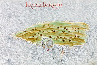
Español: Mapa español de 1632 de la isla del Barbado (actual Barbados). Página 11 de las Descripciones geográficas e hidrográficas de muchas tierras y mares del Norte y Sur en las Indias, en especial del descubrimiento del Reino de la California redactadas por el capitán Nicolás de Cardona tras su expedición de 1614.
English: Spanish 1632 map of the island of Barbados. Page 11 of the Descripciones geográficas e hidrográficas de muchas tierras y mares del Norte y Sur en las Indias, en especial del descubrimiento del Reino de la California (Geographic and hydrographic descriptions of many northern and southern lands and seas in the Indies, specifically the discovery of the kingdom of California), written by captain Nicolás de Cardona after his expedition of 1614. |
|||||||||||||||||||
| תאריך יצירה | ||||||||||||||||||||
| מקור |
Descripciones geográficas e hidrográficas de muchas tierras y mares del Norte y Sur en las Indias, en especial del descubrimiento del Reino de California hecho con trabajo e industria por el capitán y cabo Nicolás de Cardona ... dirigidas al Exmo. D. Gaspar de Guzmán, Conde de Olivares ... Biblioteca Digital Hispánica (Biblioteca Nacional de España) |
|||||||||||||||||||
| יוצר |
|
|||||||||||||||||||
רישיון
|
עבודת אמנות דו-מימדית זו המוצגת בתמונה שוחררה לרשות הציבור בכל העולם בעקבות תאריך מותו של היוצר, או תאריך פרסום היצירה. לפיכך, תצלום היצירה גם הוא ברשות הציבור.
הודעה זו תקפה לגבי התצלומים שנוצרו בארצות הברית, בגרמניה ובמדינות רבות נוספות.
| ||||
היסטוריית הקובץ
ניתן ללחוץ על תאריך/שעה כדי לראות את הקובץ כפי שנראה באותו זמן.
| תאריך/שעה | תמונה ממוזערת | ממדים | משתמש | הערה | |
|---|---|---|---|---|---|
| נוכחית | 21:26, 18 בספטמבר 2023 | | 1,953 × 2,930 (524 ק"ב) | Beao | Cropped 8 % horizontally, 10 % vertically using CropTool with lossless mode. Removed watermark. |
| 02:29, 6 במרץ 2016 |  | 2,165 × 3,184 (650 ק"ב) | Hispalois | User created page with UploadWizard |
שימוש בקובץ
הדף הבא משתמש בקובץ הזה:
שימוש גלובלי בקובץ
אתרי הוויקי השונים הבאים משתמשים בקובץ זה:
- שימוש באתר arz.wikipedia.org
- שימוש באתר as.wikipedia.org
- שימוש באתר be-tarask.wikipedia.org
- שימוש באתר bn.wikipedia.org
- שימוש באתר ceb.wikipedia.org
- שימוש באתר cs.wikipedia.org
- שימוש באתר el.wikipedia.org
- שימוש באתר en.wikipedia.org
- שימוש באתר es.wikipedia.org
- שימוש באתר eu.wikipedia.org
- שימוש באתר fr.wikipedia.org
- שימוש באתר hy.wikipedia.org
- שימוש באתר id.wikipedia.org
- שימוש באתר io.wikipedia.org
- שימוש באתר ka.wikipedia.org
- שימוש באתר ru.wikipedia.org
- שימוש באתר uk.wikipedia.org
.jpg)