
קובץ:Central Tien Shan, China.JPG

לקובץ המקורי (4,288 × 2,850 פיקסלים, גודל הקובץ: 1.92 מ"ב, סוג MIME: image/jpeg)
| זהו קובץ שמקורו במיזם ויקישיתוף. תיאורו בדף תיאור הקובץ המקורי (בעברית) מוצג למטה. |
תקציר
| תיאור |
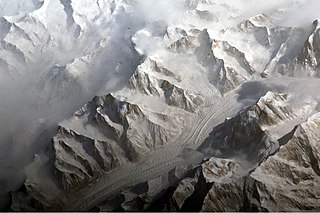
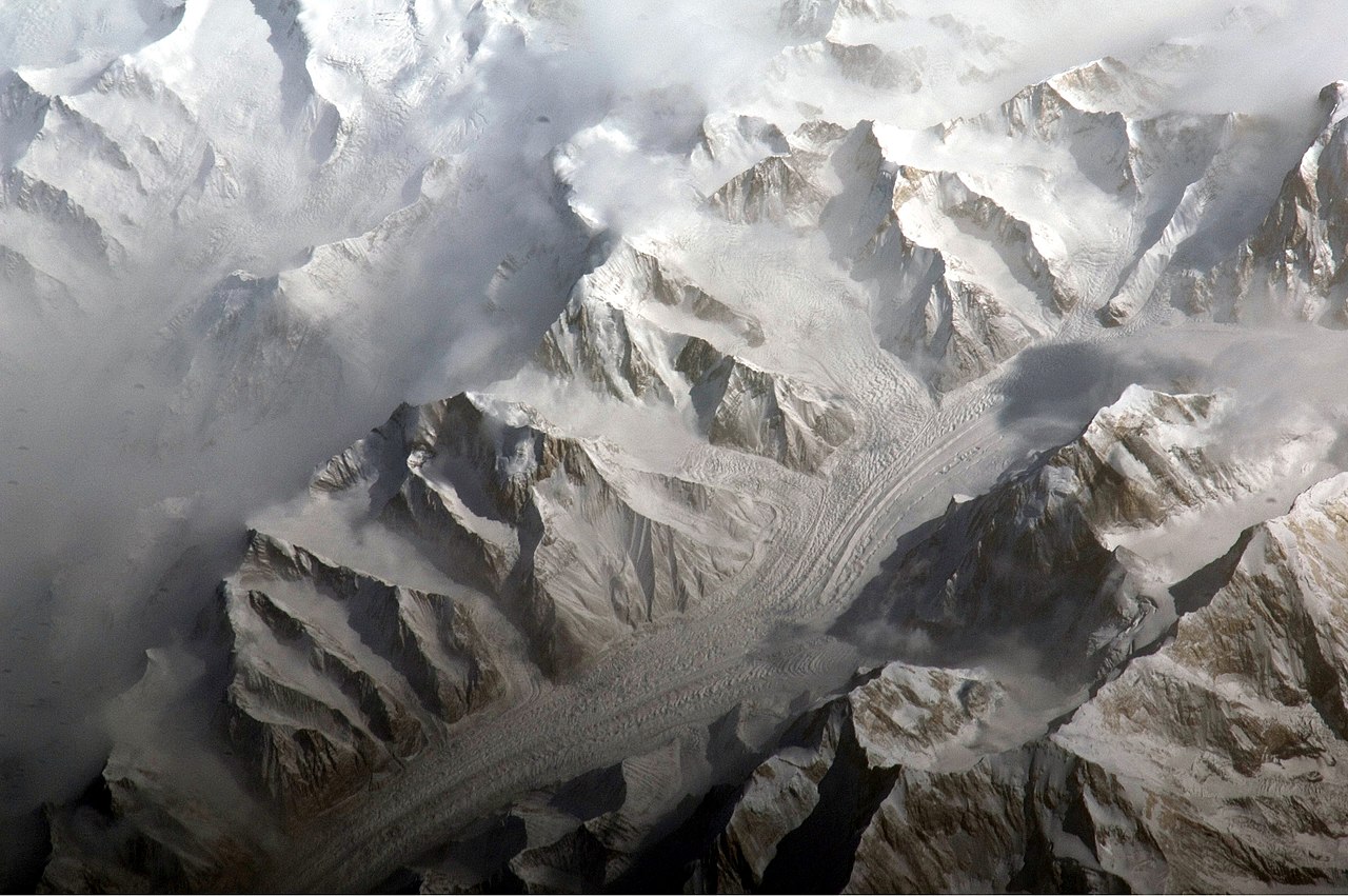
English: This astronaut photograph provides a view of the central Tien Shan, about 64 kilometres east of where the borders of China, Kyrgyzstan, and Kazakhstan meet.
While the image looks like it might have been taken from an airplane, it was taken from the International Space Station (ISS) at an altitude of 341 kilometres. The altitude plus the horizontal distance from the site—ISS was approximately 304 kilometres to the south-west—produces an oblique view. This angle, together with shadowing of valleys, accentuates the mountainous topography. Two types of glaciers are visible in the image; cirque glaciers occupy amphitheater-like depressions on the upper slopes of the mountains, and feed ice down-slope to aggregate into large valley glaciers such as the one at image centre. Low clouds obscure an adjacent valley and glaciers to the north (upper left). Two high peaks of the central Tien Shan are identifiable in the image. Xuelian Feng has a summit of 6, 527 meters above sea level. To the east, the aptly-named Peak 6231 has a summit 6,231 meters above sea level. |
| תאריך יצירה | |
| מקור | NASA Earth Observatory |
| יוצר | ISS Expedition 27 crew |
| מיקום המצלמה | | תמונה זו ותמונות נוספות במיקום: OpenStreetMap |
|---|
This image or video was catalogued by Johnson Space Center of the United States National Aeronautics and Space Administration (NASA) under Photo ID: ISS027-E-5274. This tag does not indicate the copyright status of the attached work. A normal copyright tag is still required. See Commons:Licensing. Other languages:
|
Image acquired with a Nikon D2Xs digital camera using an 800 mm lens, and is provided by the ISS Crew Earth Observations experiment and Image Science & Analysis Laboratory, Johnson Space Center.
רישיון
| קובץ זה נמצא ברשות הציבור מכיוון שהוא נוצר על ידי נאס"א. מדיניות זכויות היוצרים של נאס"א קובעת ש"חומרים של NASA אינם מוגנים בזכויות יוצרים אלא אם צוין אחרת". (דף מדיניות זכויות היוצרים ב-NASA או מדיניות שימוש בתמונות ב-JPL). | ||
 |
אזהרות:
|
| Annotations | This image is annotated: View the annotations at Commons |
היסטוריית הקובץ
ניתן ללחוץ על תאריך/שעה כדי לראות את הקובץ כפי שנראה באותו זמן.
| תאריך/שעה | תמונה ממוזערת | ממדים | משתמש | הערה | |
|---|---|---|---|---|---|
| נוכחית | 13:58, 28 במרץ 2011 | | 2,850 × 4,288 (1.92 מ"ב) | Originalwana | {{Information |Description ={{en|1=This astronaut photograph provides a view of the central Tien Shan, about 64 kilometres east of where the borders of China, Kyrgyzstan, and Kazakhstan meet. While the image looks like it might have been taken |
שימוש בקובץ
הדף הבא משתמש בקובץ הזה:
שימוש גלובלי בקובץ
אתרי הוויקי השונים הבאים משתמשים בקובץ זה:
- שימוש באתר ast.wikipedia.org
- שימוש באתר cs.wikipedia.org
- שימוש באתר de.wikipedia.org
- שימוש באתר es.wikipedia.org
- שימוש באתר fi.wikipedia.org
- שימוש באתר gl.wikipedia.org
- שימוש באתר hr.wikipedia.org
- שימוש באתר ml.wikipedia.org
- שימוש באתר mr.wikipedia.org
- שימוש באתר sr.wikipedia.org
- שימוש באתר ug.wikipedia.org
- שימוש באתר uk.wikipedia.org
- שימוש באתר www.wikidata.org